
By DONALD WITTKOWSKI
Here’s the weather forecast summed up in one word: Ugh!
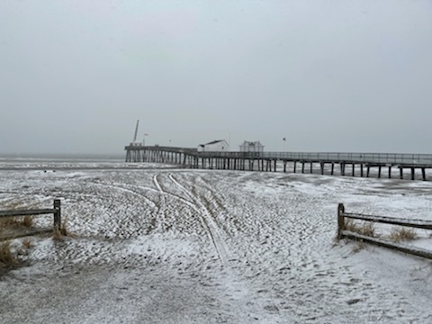
A nor’easter that began Sunday afternoon with snow covering the beaches and Boardwalk will bring a potpourri of poor weather before it finally ends on Tuesday evening, forecasters say.
Snow, rain, sleet, strong winds and flooding are expected to take turns lashing the shore while the storm lingers.
In Ocean City, emergency management officials are taking a we’re-prepared-for-anything approach to the ever-changing storm.
“There are going to be some tricky conditions out there for the next couple of days,” Ocean City Emergency Management Coordinator Frank Donato said.
The city’s Public Works crews spread sand and salt on the roads to prepare for snow and nighttime temperatures dipping below the freezing mark.
“We certainly don’t want the roads to freeze,” Donato said.
Snow is expected to mix with rain on Monday as the storm enters a more dangerous phase that will include winds gusting up to 50 mph at the shore as well as flooding.
Donato emphasized that powerful winds and flooding are the biggest concerns. Moderate flooding is expected through the high tide cycles Monday morning, Monday evening and Tuesday morning.
“The northeast wind is going to push water into the back bay and it escalates from there,” Donato noted of the flooding conditions.
The National Weather Service issued a Coastal Flood Warning in effect for Ocean City from 7 a.m. Monday through 5 p.m. Tuesday. It also issued a Wind Advisory in effect from 11 a.m. to 8 p.m. Monday for northeast winds blowing from 30 to 40 mph and gusts up to 50 mph.
According to an Ocean City flooding advisory, the National Weather Service is predicting a water level of 6.6 feet on the mean low water (MLW) scale during high tide at 10:38 a.m. Monday on the bay side of Ocean City. The forecast calls for a water level of 6.9 feet MLW at 11:15 p.m. Monday and 6.5 feet MLW at 11:28 a.m. Tuesday.
In addition, the forecast calls for minor flooding at 5.6 feet MLW at 12:07 a.m. Wednesday. By comparison, the water level reached a peak of 6.21 feet during a winter storm on Dec. 16-17, 2020. Visit www.ocnj.us/octides to compare the new predictions to other recent and historic tide levels.
“Street flooding is likely prior to high tide and may not fully drain between tide cycles,” the city’s flooding advisory says. “Vehicles should be moved from areas that typically experience tidal flooding well in advance of high tide on Monday morning. The roads closer to the beach including Central and Wesley avenues are typically at higher elevation.”
Parking will be available at the Trinity United Methodist Church at 20 North Shore Road in Marmora (read this letter from Trinity to take advantage of the parking service).
Donato said city crews cleared out storm drains in advance of the storm. They also checked the stormwater pumping stations across town to make sure they will be in good working order, he added.
Pumping stations don’t prevent flooding, but they intercept stormwater and channel it back into the bay much faster than it would normally take to drain off the streets after a coastal storm.
Ocean City’s flooding advisory urges motorists never to attempt to drive through stormwater or drive around barricades
For police and fire department emergencies, call 911. For non-emergencies, call 609-399-9111.


