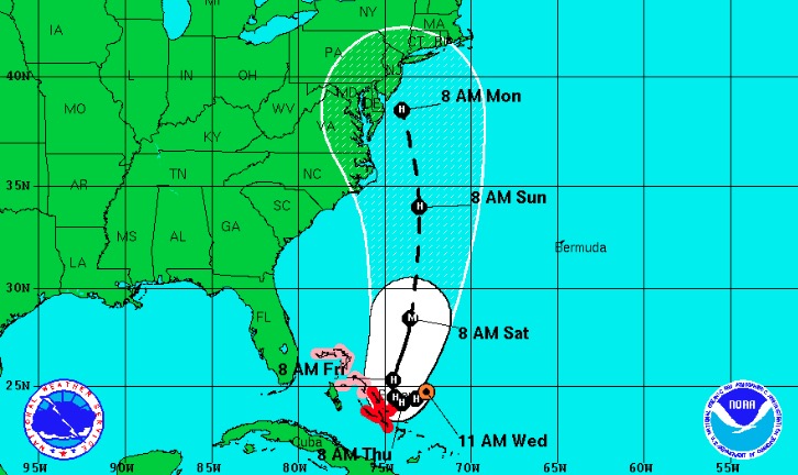
Projected track of Hurricane Joaquin from the National Hurricane Center as of Wednesday afternoon.
Ocean City is in for a long stretch of very wet and windy weather.
Heavy rain and gale-force winds blowing off the ocean highlight the forecast through Saturday, and an approaching hurricane could intensify and extend the same conditions.
As usual on the low-lying barrier island, tidal flooding is the greatest threat to Ocean City.
Residents and visitors should be aware of the following high tides and be prepared to move vehicles from flood-prone streets (particularly during heavy rainfall):
- Wednesday: 10:55 p.m.
- Thursday: 11:19 a.m. and 11:49 p.m.
- Friday: 12:13 p.m.
- Saturday: 12:45 a.m. and 1:08 p.m.
- Sunday: 1:42 a.m. and 2:05 p.m.
A National Weather Service briefing released at noon Wednesday suggests the region could see 4 to 10 inches of rain this week with 20 to 30 mph winds gusting beyond 45 mph along the coastline by Thursday and Friday.
"Moderate coastal flooding is possible on Thursday," the NWS reports in its briefing. "Moderate to major coastal flooding is now possible on Friday with the strong northeast winds. This is in advance of any impacts from Hurricane Joaquin. If Hurricane Joaquin directly affects the region, major to record coastal flooding is possible."
"Moderate flooding" is generally considered 6.5 to 7.5 feet on the Mean Low Water scale. See
OCNJ Daily's chart of record flood levels for comparison to other historic and recent storms. Ocean City last saw moderate flooding in January 2015 and December 2014. "Major flooding" is beyond 7.5 feet on the MLW scale. Superstorm Sandy hit a record 10.02 feet on the MLW scale.
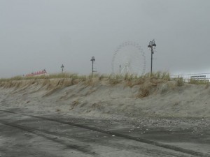
Clouds move in over the Boardwalk at Fifth Street on Wednesday afternoon.
The NWS forecast calls for rain in each of the next six days with the heaviest downpours likely on Thursday and Friday. The marine forecast suggests sustained northeast winds on Friday could be 25 to 40 mph with stronger gusts. The offshore wave heights will reach 11 to 16 feet by Friday night, according to the marine forecast.
That forecast does not take into account the possible effects of Hurricane Joaquin, which was a Category 3 storm with 120 mph winds on Thursday morning. The projected track of Joaquin is northward, possibly making landfall anywhere from the Carolinas to New Jersey or possibly remaining at sea.
The storm would impact Ocean City on Sunday into Monday, according to the NWS briefing, but its rain and wind would begin to be felt as early as Friday.
The southern end of Ocean City recently completed a beach replenishment project, and the new sand will be put to the test. The northern end of Ocean City already is seeing erosion from a week-long northeast swell.
Read statement from the Ocean City Office of Emergency Management.
______
Sign up for free breaking news alerts and daily updates on Ocean City news.
 Clouds move in over the Boardwalk at Fifth Street on Wednesday afternoon.
The NWS forecast calls for rain in each of the next six days with the heaviest downpours likely on Thursday and Friday. The marine forecast suggests sustained northeast winds on Friday could be 25 to 40 mph with stronger gusts. The offshore wave heights will reach 11 to 16 feet by Friday night, according to the marine forecast.
That forecast does not take into account the possible effects of Hurricane Joaquin, which was a Category 3 storm with 120 mph winds on Thursday morning. The projected track of Joaquin is northward, possibly making landfall anywhere from the Carolinas to New Jersey or possibly remaining at sea.
The storm would impact Ocean City on Sunday into Monday, according to the NWS briefing, but its rain and wind would begin to be felt as early as Friday.
The southern end of Ocean City recently completed a beach replenishment project, and the new sand will be put to the test. The northern end of Ocean City already is seeing erosion from a week-long northeast swell.
Read statement from the Ocean City Office of Emergency Management.
______
Sign up for free breaking news alerts and daily updates on Ocean City news.
Clouds move in over the Boardwalk at Fifth Street on Wednesday afternoon.
The NWS forecast calls for rain in each of the next six days with the heaviest downpours likely on Thursday and Friday. The marine forecast suggests sustained northeast winds on Friday could be 25 to 40 mph with stronger gusts. The offshore wave heights will reach 11 to 16 feet by Friday night, according to the marine forecast.
That forecast does not take into account the possible effects of Hurricane Joaquin, which was a Category 3 storm with 120 mph winds on Thursday morning. The projected track of Joaquin is northward, possibly making landfall anywhere from the Carolinas to New Jersey or possibly remaining at sea.
The storm would impact Ocean City on Sunday into Monday, according to the NWS briefing, but its rain and wind would begin to be felt as early as Friday.
The southern end of Ocean City recently completed a beach replenishment project, and the new sand will be put to the test. The northern end of Ocean City already is seeing erosion from a week-long northeast swell.
Read statement from the Ocean City Office of Emergency Management.
______
Sign up for free breaking news alerts and daily updates on Ocean City news.


