
By Donald Wittkowski
City Council introduced an ordinance Tuesday to bring Ocean City in line with the federal government’s new flood maps for the National Flood Insurance Program.
Utilizing the latest mapping technology, the Federal Emergency Management Agency is updating the nation’s flood maps for the first time since 1984 to reflect the current flooding risks to coastal communities.
“Flood hazard mapping is an important part of the National Flood Insurance Program (NFIP), as it is the basis of the NFIP regulations and flood insurance requirements,” FEMA says on its website.
Ocean City’s new ordinance will update the town’s existing flood damage prevention program to comply with FEMA’s new mapping requirements taking effect on Oct. 5. The ordinance was unanimously introduced by Council and is up for a public hearing and final vote on Sept. 14.
In Ocean City, some of the areas considered high-risk flooding zones are shifting as part of the new mapping program. Most significantly, a swath of town along Bay Avenue between Ninth Street and Battersea Road and a few other smaller pockets on the bayfront will now be incorporated into FEMA’s so-called “Coastal A” Zone, city spokesman Doug Bergen said.
Property owners within the “Coastal A” Zone who do extensive renovations to their homes or build new houses there will have to meet stricter construction requirements as part of their flood insurance coverage.
Bergen explained that “Coastal A” Zone homeowners would have to elevate their houses on piles for their construction projects. They would also have to build walls that would “break away” on the ground level if struck by strong waves, a feature that would allow the water to sweep under the rest of the house and save the remaining structure, Bergen noted.
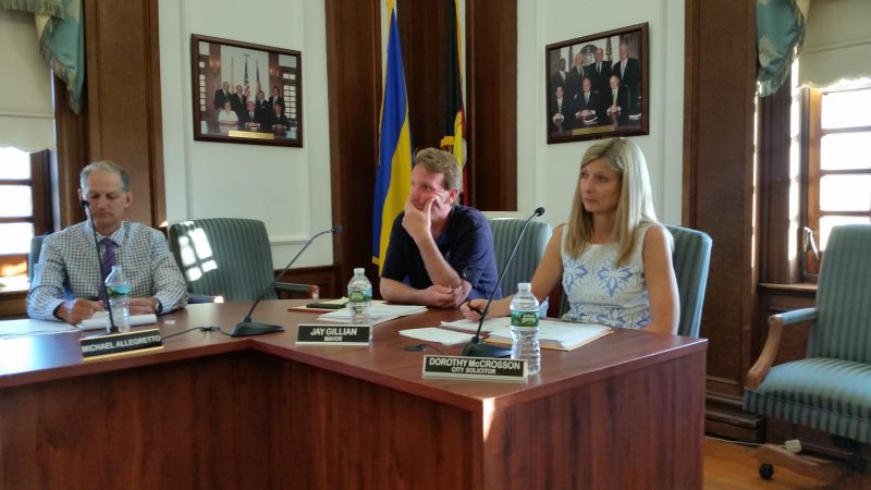
Property owners in flooding zones who don’t build new houses or do extensive renovation work to their existing homes would not be affected by FEMA’s new mapping program, Ocean City Solicitor Dorothy McCrosson told Council.
McCrosson also said she doesn’t expect that flood insurance premiums will increase as a result of changes to the FEMA maps.
Communities that are part of the National Flood Insurance Program are ranked by FEMA based on the flood-control measures they have at the local level. The ranking system allows homeowners to get discounts in their flood insurance coverage. Homeowners in Ocean City receive a 25 percent discount.
The National Flood Insurance Program, meanwhile, is $25 billion in debt and would have to be renewed by Congress if it is to continue beyond its scheduled Sept. 30 expiration date. Debate continues in Washington whether the program should remain under government control or be privatized.
In other business Tuesday, Council approved a new agreement that will bring more than $1 million in state funding for a major dredging project to clear out sediment-choked lagoons along Ocean City’s back bays.
Under the pact, the New Jersey Department of Transportation’s Office of Maritime Resources will kick in $1.3 million toward the nearly $1.5 million total cost to dredge the Carnival Bayou lagoon.
The DOT will help pay for the project because the dredging work will also clear out sediment from state channels along the city’s back bays.
“The NJDOT will pay for all eligible costs attributable to dredging the State Channels,” the agreement says.
Those costs include designs, permitting, testing and inspection for the project, as well as the actual dredging work itself, the agreement notes.
Bergen said the DOT funding was “a pleasant surprise” for the city.
Carnival Bayou, between 16th and 17th streets, is one of three major dredging projects planned by the city beginning in September. South Harbor, between Tennessee Avenue and Spruce Road, and Sunny Harbor, between Arkansas Avenue and Walnut Road, are the other two.
Mayor Jay Gillian told Council that it appears the DOT funding will be limited to the Carnival Bayou project, although the city has not ruled out the possibility that even more money could come from the state for other dredging work.
“We’re still sticking to our plan, hoping to add more,” Gillian said.
In a related matter Tuesday, Council awarded a $732,514 contract to Mobile Dredging & Pumping Co. of Chester, Pa., for dredging work at Carnival Bayou. Mobile Dredging submitted the lowest bid among three contractors that sought the work, according to documents attached to Council’s agenda.
The city began the first round of dredging last year as part of a $20 million program proposed by the mayor for 2016, 2017 and 2018. In 2017, the town plans to spend $7.5 million for dredging projects, said Frank Donato, the city’s chief financial officer.
The city has permits for the dredging projects at Carnival Bayou, South Harbor and Sunny Harbor this year. Last December, the city applied for a permit from the New Jersey Department of Environmental Protection and U.S. Army Corps of Engineers to conduct dredging along the entire length of the island. City officials expect to receive word by year’s end whether that permit has been approved.


