
[Best_Wordpress_Gallery id=”14″ gal_title=”October 2015 Storm Friday”]
Ocean City saw its highest tide of the year Friday at 12:30 p.m., and many streets were flooded. But a relentless northeast gale reserved its best punch for Ocean City’s beaches.
Just three days after the completion of a massive $57 million Army Corps of Engineers project to rebuild beaches at the southern end of Ocean City, Strathmere and Sea Isle City, the new sand is underwater. The ocean was lapping at the newly constructed dune line at high tide on Friday.
From north to south in Ocean City, the beach had disappeared under a storm swell churned up by northeast winds between 25 and 35 mph on Friday. The peak wind speed on Friday at 59th Street Beach was 47 mph and was recorded at 12:58 p.m.
Ocean City has been in the gap between high and low pressure systems for more than a week, and the resulting wind and waves have battered the coast. The conditions likely peaked with Friday’s high tide, but the gale will continue through the weekend.
Peak tide level: 7.35 feet (Mean Low Water) at 12:30 p.m. Friday, Oct. 2. Then 7.09 feet at 12:54 a.m. on Saturday, Oct. 3.
(See tide level in real time at the Bayside Center on the 500 block of Bay Avenue in Ocean City. Add 2.77 to convert NAVD88 readings to MLW.)
How high is that tide? The 7.35 feet is the highest tide of the calendar year. It falls in what forecasters call “moderate tidal flooding” range of 6.5 feet to 7.5 feet. Superstorm Sandy, by comparison, was a record 10.02 feet on the MLW scale, and the memorable November 2009 nor’easter was 8.02 feet. (See OCNJ Daily’s chart of historic and recent record flood levels.)
Observations: Travel on many parts of West, Haven, Simpson and Bay avenues was difficult early Friday afternoon with salt water covering long stretches of the roadways. But the flood was not substantially greater than what Ocean City sees during the biggest storms of any year. Rainfall was light through the early afternoon with the accumulated total from midnight to noon about a quarter inch. A slight shift in the wind direction from northeast to north may have helped prevent more flooding.
Streets closer to the beach (Wesley and Central avenues) provided the highest and driest routes the length of town.
The greatest impact from the storm seems to be on the beaches. The elevation of the rebuilt beaches at the south end was holding back the waves, but it could not prevent water from flowing across the wide expanses of new sand to the edge of the new dunes. How much sand was moved or lost won’t be fully evident until the swell subsides.
With the whitecaps of breaking waves stretching to the horizon, the north end beaches took a hit. The waves carved into the dunes at Waverly, Fifth Street and Sixth Street. The swell buried jetties and covered the downtown beaches between Ninth and 14th streets.
On the bay side, the tide appeared to rise to just a foot or two below the tops of the bulkheads.
The Forecast: The National Weather Service forecast calls for the chance of heavy rain to greatly diminish, but not the wind. The coast can expect sustained wind at 30 to 40 mph gusting beyond 50 mph.
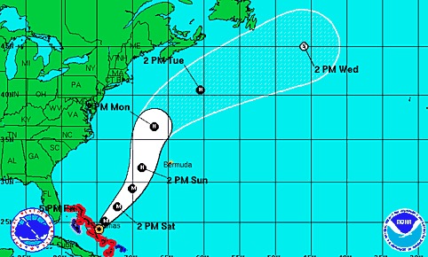
Projected track of Hurricane Joaquin as of Friday evening.Ocean City can expect street flooding similar to Friday’s at high tide at 12:45 a.m. and 1:08 p.m. on Saturday.
Unrelated to the northeast gale, Category 4 Hurricane Joaquin had sustained winds of 130 mph as it battered the Bahamas early Friday. Forecasters as of Friday were favoring a track that would pass by Ocean City far out over the open ocean.
Big waves generated by the passing hurricane likely would affect Ocean City on Sunday and Monday. But the very strong local northeast winds in the forecast through Monday would make surfing conditions less than ideal.
National Weather Service Briefing: Read the most current briefing from the NWS.
High Tides: Residents and visitors should be aware of the following high tides (on Ocean City’s bay side at the Ninth Street Bridge) and be prepared to move vehicles from flood-prone streets (particularly during heavy rainfall):
- Saturday: 12:45 a.m. and 1:08 p.m.
- Sunday: 1:42 a.m. and 2:05 p.m.
Follow OCNJ Daily
Sign up for our free news updates from Ocean City. Check back with OCNJ Daily for photographs and reports on real-time conditions in Ocean City.
Postponements:
- The Ocean City School District will be closed on Friday.
- The Bike MS: City to Shore ride has been cancelled with no reschedule date.
- The HERO Foundation Walk has been rescheduled for Saturday, Oct. 10.
- The Ocean City Firefighters’ glowball golf event for Operation First Response has been postponed until Friday, Oct. 9.
- A Clean Ocean Action check presentation at Henry’s on the Boardwalk has been postponed with a rescheduled date to be determined.
- All games and practices for Ocean City Intermediate School have been cancelled for Thursday.
- The Ocean City High School away football game at St. Augustine’s Prep (originally scheduled for Friday) has been rescheduled for Thursday (Oct. 1) at 6 p.m.
- OCHS soccer and tennis games are postponed.
Ocean City Emergency Management Statement:


