A continuous sledding track was hard to come by Tuesday morning in Ocean City, as wind blew some areas clean of a light coating of snow.
After forecasts of as much of 14 inches of snow from a much-hyped Winter Storm “Juno,” Ocean City escaped the worst of the coastal blizzard.
The storm left about 2 inches of snow in Ocean City overnight Monday in to the wee hours of Tuesday morning. By mid-morning Tuesday, all roads were clear.
The National Weather Service all along had warned that the track of the storm was uncertain, but when they upped their snowfall projections from about four inches to 14 inches on Monday, the Ocean City School District cancelled classes for all schools on Tuesday. The Ocean City Free Public Library and the Ocean City Municipal Court also announced closings for Tuesday.

The Ocean City School District cancelled classes for Tuesday, but by mid-morning, roads were clear outside Ocean City High School.
The storm system tracked farther out to sea than anticipated, and it appears that New England will bear the brunt of the storm. The sun was burning through cloud cover in Ocean City by late Tuesday morning.
__________
A few flakes of snow fell at dawn on Monday, but the precipitation turned to rain for most of the day. The rain and wind grew stronger through the day but began to fade in the evening.
Ocean City schools cancelled some after-school activities and rescheduled others on Monday. The Ocean City Police Department warned residents not to park on West Avenue, an emergency route, if snow covered the street.
Forecasters also warned of moderate tidal flooding — even though the predicted tide levels were not particularly high at a period halfway between a new moon and full moon. But the northeast winds that were expected to create a storm surge of a few extra feet were not quite as strong as expected.

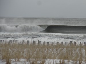
Clean surf on Tuesday morning at Fourth Street in Ocean City, NJ.
One NOAA model projected a tide in Atlantic City approaching 7 feet on the mean low water scale. But the tide in Ocean City reached only 6.58 feet at the Bayside Center in Ocean City at 1:36 a.m., a few minutes after high tide.
By comparison, the Dec. 9, 2014 nor’easter in Ocean City saw a peak MLW reading of 7.29 feet.
See where this storm stacks up against others in terms of water level:
Ocean City Record Flood Levels.
Streets along the bay and on the low-lying Simpson and Haven avenues saw flooding in the wee hours of Tuesday morning, but nothing as severe as during a handful of other storms in the past year.
The forecast calls for some chance of continued snow on Tuesday with a high temperature of 31 degrees. The low is expected to fall to 17 degrees on windy and cold Tuesday night.
The sun will return on Wednesday with a high of 29 degrees, according to the NWS.
The storm did generate some surf -- and with light offshore winds blowing Tuesday morning, conditions were good.
 The Ocean City School District cancelled classes for Tuesday, but by mid-morning, roads were clear outside Ocean City High School.
The storm system tracked farther out to sea than anticipated, and it appears that New England will bear the brunt of the storm. The sun was burning through cloud cover in Ocean City by late Tuesday morning.
__________
 Clean surf on Tuesday morning at Fourth Street in Ocean City, NJ.
One NOAA model projected a tide in Atlantic City approaching 7 feet on the mean low water scale. But the tide in Ocean City reached only 6.58 feet at the Bayside Center in Ocean City at 1:36 a.m., a few minutes after high tide.
By comparison, the Dec. 9, 2014 nor’easter in Ocean City saw a peak MLW reading of 7.29 feet.
See where this storm stacks up against others in terms of water level: Ocean City Record Flood Levels.
Streets along the bay and on the low-lying Simpson and Haven avenues saw flooding in the wee hours of Tuesday morning, but nothing as severe as during a handful of other storms in the past year.
The forecast calls for some chance of continued snow on Tuesday with a high temperature of 31 degrees. The low is expected to fall to 17 degrees on windy and cold Tuesday night.
The sun will return on Wednesday with a high of 29 degrees, according to the NWS.
The storm did generate some surf -- and with light offshore winds blowing Tuesday morning, conditions were good.