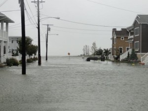
An abandoned car sits in the middle of Fourth Street on Saturday afternoon as a northeast gale continues to cause exceptionally high tides and street flooding in Ocean City.
Ocean City endured another day of flooded streets and eroding beaches Saturday as an unending northeast gale continued to batter the coastline.
The region has been in the gap between high- and low-pressure weather systems for about two weeks now. The margin between the two swirling systems has been characterized by strong winds blowing relentlessly off the ocean.
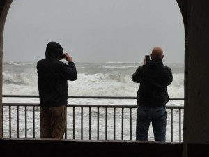
The ocean was white to the horizon with breaking waves on Saturday, and the stormy surf continued to carve away beaches and dunes across the length of the island. The wind is pushing water into the back bays and causing the highest tides in more than two years.
The water level on the bay side topped out at 7.21 feet on the mean low water scale at 1:18 p.m. Saturday afternoon, just below Friday afternoon's 7.35 feet. The exceptionally high tide flooded streets on the bay side of Ocean City for most of the afternoon.

The Ocean City Music Pier offered a little shelter for onlookers taking in the power of the surf during a continuing northeast gale in Ocean City on Saturday, Oct. 3, 2015.
The wind is not expected to relent on Sunday, and the waves pounding at the beaches could start to be strengthened by swell from distant Hurricane Joaquin.
Peak tide level: 7.21 feet (Mean Low Water) at 1:18 p.m. Saturday, Oct. 3.
(
See tide level in real time at the Bayside Center on the 500 block of Bay Avenue in Ocean City. Add 2.77 to convert NAVD88 readings to MLW.)
How high is that tide? The 7.21 feet is the second highest tide of the calendar years 2014 and 2015 (behind only Friday's 7.35 feet). It falls in what forecasters call “moderate tidal flooding” range of 6.5 feet to 7.5 feet. Superstorm Sandy, by comparison, was a record 10.02 feet on the MLW scale, and the memorable November 2009 nor’easter was 8.02 feet. (
See OCNJ Daily’s chart of historic and recent record flood levels.)
Observations: Asbury Avenue seemed to mark the dividing line between flooded streets and safe travel. Long stretches of flood-prone Haven and Simpson avenues were under knee- to thigh-deep water. But even many parts of the well-traveled thoroughfares Bay and West avenues were covered by salt water.

The bay tops the bulkhead at 11th Street during high tide early Saturday afternoon.
At some street ends such as 11th Street, the bay topped the bulkhead. At a couple different spots, cars were abandoned in the middle of flooded streets. The tide did not, however, appear to threaten much property on the island.
On the beaches, the storm swell continued to threaten beaches. At high tide, there was virtually no beach anywhere on the island. The waves continued to erode dunes on the north end, where a regularly scheduled beach renourishment project is expected to begin later this month.
At the south end, where a massive beach replenishment project was just completed, the new beach held back the storm surge as it was designed to do, and a new frontal dune appears to be intact. It will be hard to tell what effect the storm has had on the size and shape of the new beaches until the swell subsides.
The Forecast: The National Weather Service forecast calls for a chance of light rain through most of Sunday. The coast can expect more sustained winds at 30 to 40 mph gusting beyond 45 mph.
Ocean City can expect more street flooding similar to Saturday’s at high tides at 1:42 a.m. and 2:05 p.m. on Sunday.
Unrelated to the northeast gale, Category 4 Hurricane Joaquin had sustained winds of 155 mph as it moved away from the Bahamas on Saturday afternoon. The projected track of the storm passes by Ocean City far out over the open ocean.
Big waves generated by the passing hurricane likely would affect Ocean City on late Sunday and Monday. But the very strong local northeast winds in the forecast through Monday would make surfing conditions less than ideal.
National Weather Service Briefing: Read the most current briefing from the NWS.
High Tides: Residents and visitors should be aware of the following high tides (on Ocean City’s bay side at the Ninth Street Bridge) and be prepared to move vehicles from flood-prone streets (particularly during heavy rainfall):
- Sunday: 1:42 a.m. and 2:05 p.m.
- Monday: 2:41 a.m. and 3:04 p.m.
Follow OCNJ Daily
Sign up for our free news updates from Ocean City. Check back with OCNJ Daily for photographs and reports on real-time conditions in Ocean City.
 The Ocean City Music Pier offered a little shelter for onlookers taking in the power of the surf during a continuing northeast gale in Ocean City on Saturday, Oct. 3, 2015.
The wind is not expected to relent on Sunday, and the waves pounding at the beaches could start to be strengthened by swell from distant Hurricane Joaquin.
Peak tide level: 7.21 feet (Mean Low Water) at 1:18 p.m. Saturday, Oct. 3.
(See tide level in real time at the Bayside Center on the 500 block of Bay Avenue in Ocean City. Add 2.77 to convert NAVD88 readings to MLW.)
How high is that tide? The 7.21 feet is the second highest tide of the calendar years 2014 and 2015 (behind only Friday's 7.35 feet). It falls in what forecasters call “moderate tidal flooding” range of 6.5 feet to 7.5 feet. Superstorm Sandy, by comparison, was a record 10.02 feet on the MLW scale, and the memorable November 2009 nor’easter was 8.02 feet. (See OCNJ Daily’s chart of historic and recent record flood levels.)
Observations: Asbury Avenue seemed to mark the dividing line between flooded streets and safe travel. Long stretches of flood-prone Haven and Simpson avenues were under knee- to thigh-deep water. But even many parts of the well-traveled thoroughfares Bay and West avenues were covered by salt water.
