Fourth Ward Councilman Dave Winslow addresses the audience at the community meeting.
 By DONALD WITTKOWSKI
A walk along the Crook Horn Creek Nature Trail reveals the ghostly remnants of an old railroad line, a thicket of tall cedar trees and striking views of the wetlands that unfold for miles in the south end of Ocean City.
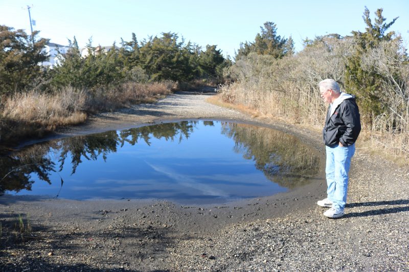
The trail actually is an old railroad service road that runs parallel to the abandoned train tracks at the bay end of 51st Street and extends past 52nd Street. Dotted with rain puddles, the badly rutted dirt road has been closed to traffic for years and now serves as a pathway for hikers, nature lovers, anglers and bicyclists.
Despite its deteriorated condition, Ocean City officials believe the trail can be transformed into a natural-looking barrier that will help protect the southern tip of town from floodwater seeping out of the wetlands.
At a community meeting Saturday, city officials outlined their plans to use a $580,000 state grant to create a raised berm, or “vegetated wall,” along the Crook Horn Creek Nature Trail for better storm protection for the homes in the surrounding area.
“This is just one of many projects the city is undertaking to alleviate flooding,” Fourth Ward City Councilman Dave Winslow, who represents the south end of town, told the audience.

Fourth Ward Councilman Dave Winslow addresses the audience at the community meeting.
However, local residents attending the meeting at the American Legion Post 525 hall reacted skeptically to the plan. They peppered city officials and representatives of an engineering firm with pointed questions.
Residents voiced concerns about the environmental impacts of such a project, including whether the berm would be properly maintained and whether it might make flooding even worse near their homes.
Jeff Travaline, a resident of Dory Drive who lives near the trail, said he is worried that the project may simply lead to more traffic invading the neighborhoods and creating parking shortages. He also fears that by attracting more people to the trail, there will be more trash left behind.
“How is it going to be maintained for trash? I already go out there and pick up the trash sometimes,” Travaline said in an interview.
Donna Moore, a local resident and environmental advocate, said she believes the project would ultimately prove bad for the wetlands, and possibly wildlife and the island’s natural vegetation as well.
“I really treasure our wetlands, and this will forever change our wetlands,” Moore said in an interview.

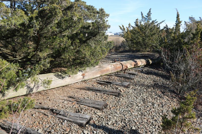
Running parallel to the trail is an old railway and its abandoned train tracks.
Nick Brown, director of coastal geology and resiliency for ACT Engineers Inc., the consulting company helping the city with the project, repeatedly assured the audience that the plan will not have an adverse impact on wetlands.
“The goal is to improve our wetlands,” Brown said.
George Savastano, the city’s business administrator followed up Brown’s comment by telling the residents, “We’re not going to make negative changes. So, that’s not part of the design.”
Cards were distributed at the meeting to allow residents to fill out questions and comments about the project for public feedback. The cards will be sent to ACT Engineers to provide answers to any questions.
Major goals for the project include improving the old service road to create a multipurpose trail with ADA accessibility. The upgrades will provide recreational opportunities while also improving storm protection for nearby homes.
Crook Horn Creek Nature Trail extends beyond 51st Street to the end of 52nd Street past Dory Drive. The flood-prone area abuts a huge expanse of wetlands stretching for miles out to the Intracoastal Waterway.

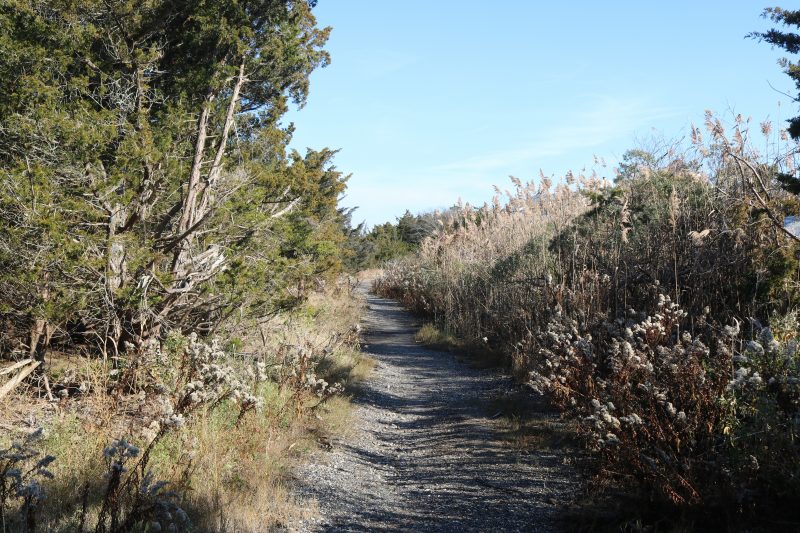
The dirt trail is lined by a thicket of cedar trees, marsh reeds and vegetation.
Jeff Richter, director of engineering for ACT Engineers, said the project calls for raising the nature trail to create a flood-resistant berm – or wall – that that would run parallel to 52nd Street from 51st Street.
Richter explained that the berm will have the dual benefit of stabilizing the trail and providing better flood protection. Dirt, vegetation and other natural materials would be used to make the berm more natural-looking, he said.
The trail is currently 4 to 5 feet high and will be raised to 7 feet – an elevation consistent with the minimum bulkhead heights required by Ocean City, according to a summary of the project. Improvements would be done within the footprint of the old service road.
The old railroad line, which once served trains coming from Philadelphia to Ocean City, but was abandoned in the 1980s, will not be disturbed by the project. Trees along the old railroad tracks would also be left alone, the summary says.
Designs for the project are tentatively scheduled for completion in the spring of 2024. Bids would go out in the summer of 2024, with construction getting underway in the fall of 2024.

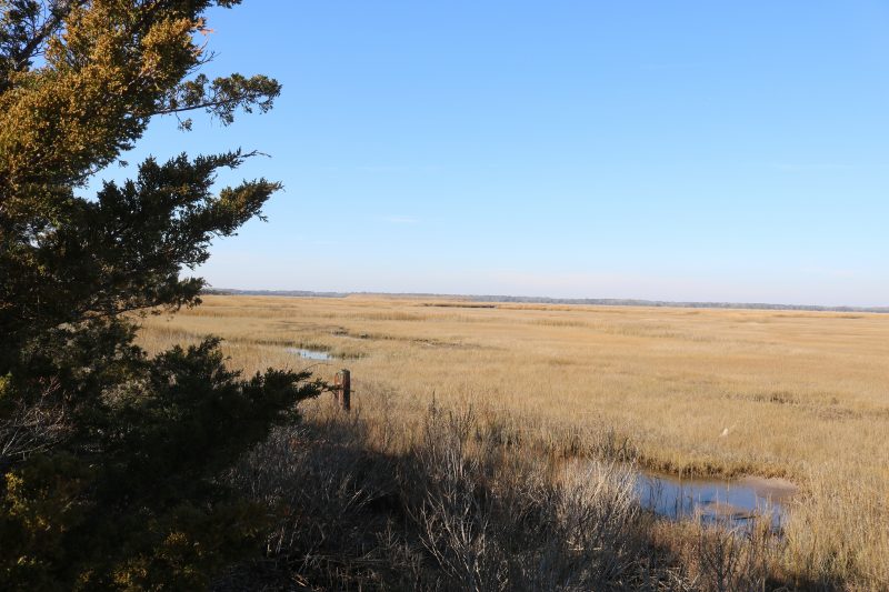
Panoramic views of the surrounding wetlands unfold from the nature trail.
Tom Murphy, a resident of Brigantine Drive for 10 years, said he enjoys the panoramic views of the wetlands from his home. He would prefer that the city leave the trail alone.
“This is the nice view from my kitchen table. I love it. I don’t want to see them change it,” Murphy said while walking on the trail Saturday.
At the same time, Murphy indicated he is willing to give the city a chance to show that the project would actually improve the trail – and provide a benefit to the south end homeowners by creating better flood protection and more recreational opportunities.
“It doesn’t sound like it would be terribly invasive or destructive,” he said.
 By DONALD WITTKOWSKI
A walk along the Crook Horn Creek Nature Trail reveals the ghostly remnants of an old railroad line, a thicket of tall cedar trees and striking views of the wetlands that unfold for miles in the south end of Ocean City.
The trail actually is an old railroad service road that runs parallel to the abandoned train tracks at the bay end of 51st Street and extends past 52nd Street. Dotted with rain puddles, the badly rutted dirt road has been closed to traffic for years and now serves as a pathway for hikers, nature lovers, anglers and bicyclists.
Despite its deteriorated condition, Ocean City officials believe the trail can be transformed into a natural-looking barrier that will help protect the southern tip of town from floodwater seeping out of the wetlands.
At a community meeting Saturday, city officials outlined their plans to use a $580,000 state grant to create a raised berm, or “vegetated wall,” along the Crook Horn Creek Nature Trail for better storm protection for the homes in the surrounding area.
“This is just one of many projects the city is undertaking to alleviate flooding,” Fourth Ward City Councilman Dave Winslow, who represents the south end of town, told the audience.
 Fourth Ward Councilman Dave Winslow addresses the audience at the community meeting.
However, local residents attending the meeting at the American Legion Post 525 hall reacted skeptically to the plan. They peppered city officials and representatives of an engineering firm with pointed questions.
Residents voiced concerns about the environmental impacts of such a project, including whether the berm would be properly maintained and whether it might make flooding even worse near their homes.
Jeff Travaline, a resident of Dory Drive who lives near the trail, said he is worried that the project may simply lead to more traffic invading the neighborhoods and creating parking shortages. He also fears that by attracting more people to the trail, there will be more trash left behind.
“How is it going to be maintained for trash? I already go out there and pick up the trash sometimes,” Travaline said in an interview.
Donna Moore, a local resident and environmental advocate, said she believes the project would ultimately prove bad for the wetlands, and possibly wildlife and the island’s natural vegetation as well.
“I really treasure our wetlands, and this will forever change our wetlands,” Moore said in an interview.
 Running parallel to the trail is an old railway and its abandoned train tracks.
Nick Brown, director of coastal geology and resiliency for ACT Engineers Inc., the consulting company helping the city with the project, repeatedly assured the audience that the plan will not have an adverse impact on wetlands.
“The goal is to improve our wetlands,” Brown said.
George Savastano, the city’s business administrator followed up Brown’s comment by telling the residents, “We’re not going to make negative changes. So, that’s not part of the design.”
Cards were distributed at the meeting to allow residents to fill out questions and comments about the project for public feedback. The cards will be sent to ACT Engineers to provide answers to any questions.
Major goals for the project include improving the old service road to create a multipurpose trail with ADA accessibility. The upgrades will provide recreational opportunities while also improving storm protection for nearby homes.
Crook Horn Creek Nature Trail extends beyond 51st Street to the end of 52nd Street past Dory Drive. The flood-prone area abuts a huge expanse of wetlands stretching for miles out to the Intracoastal Waterway.
 The dirt trail is lined by a thicket of cedar trees, marsh reeds and vegetation.
Jeff Richter, director of engineering for ACT Engineers, said the project calls for raising the nature trail to create a flood-resistant berm – or wall – that that would run parallel to 52nd Street from 51st Street.
Richter explained that the berm will have the dual benefit of stabilizing the trail and providing better flood protection. Dirt, vegetation and other natural materials would be used to make the berm more natural-looking, he said.
The trail is currently 4 to 5 feet high and will be raised to 7 feet – an elevation consistent with the minimum bulkhead heights required by Ocean City, according to a summary of the project. Improvements would be done within the footprint of the old service road.
The old railroad line, which once served trains coming from Philadelphia to Ocean City, but was abandoned in the 1980s, will not be disturbed by the project. Trees along the old railroad tracks would also be left alone, the summary says.
Designs for the project are tentatively scheduled for completion in the spring of 2024. Bids would go out in the summer of 2024, with construction getting underway in the fall of 2024.
 Panoramic views of the surrounding wetlands unfold from the nature trail.
Tom Murphy, a resident of Brigantine Drive for 10 years, said he enjoys the panoramic views of the wetlands from his home. He would prefer that the city leave the trail alone.
“This is the nice view from my kitchen table. I love it. I don’t want to see them change it,” Murphy said while walking on the trail Saturday.
At the same time, Murphy indicated he is willing to give the city a chance to show that the project would actually improve the trail – and provide a benefit to the south end homeowners by creating better flood protection and more recreational opportunities.
“It doesn’t sound like it would be terribly invasive or destructive,” he said.