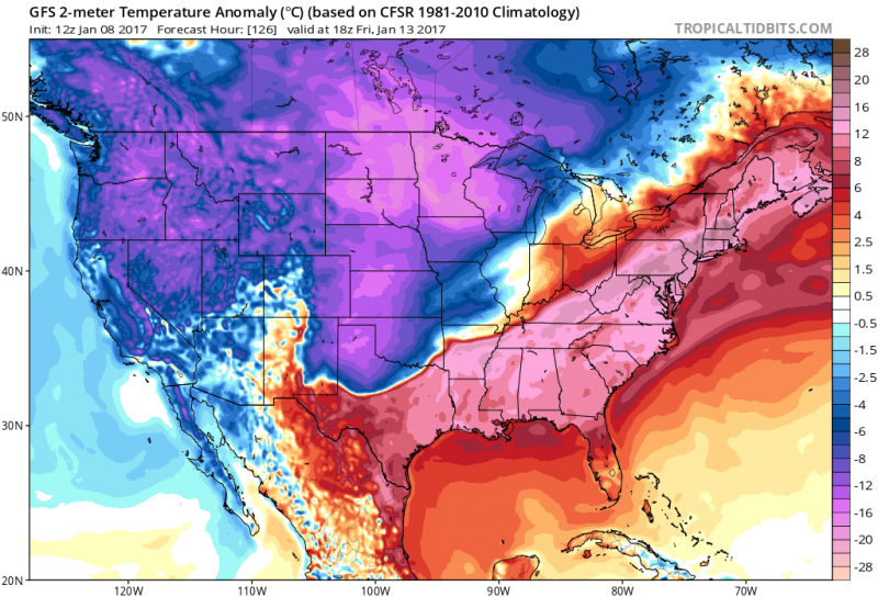
Now that the weekend winter storm is past us, it time to look ahead to this week. We will have one more day of frigid temperatures before the freeze eases. High temperatures on Monday will struggle to reach 30 degrees despite another bright sunny day. Watch for re-freezing at night as any melting that occurs during the day will ice up again after dark.
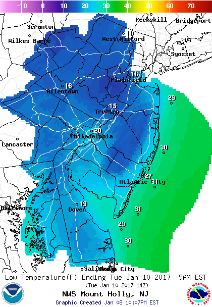 Lows Tuesday morning, not as frigid, but still below freezing.
Tuesday morning will probably be our last time we will see temperatures below freezing for at least the next 10 days as High Pressure slides off the coast and southwest winds will begin to erode the frigid air. This will allow temperatures will climb back above normal (mid 40s).
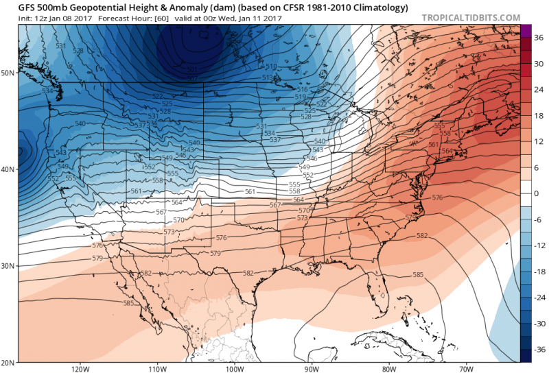 Computer models show a ridge of High Pressure off of the Southeast U.S. which pushes milder air into our area. (Courtesy:tropicaltidbits.com)
Major melting by Wednesday as a warm front moves through bringing a period of rain in the morning and afternoon temperatures climbing to around 50 degrees!
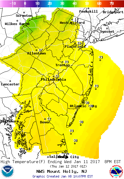
For the remainder of the week, a mild southwest flow will keep high temperatures in the upper 50s (possible 60) for Thursday and Friday. A cold front will approach late Friday with the threat of some showers.
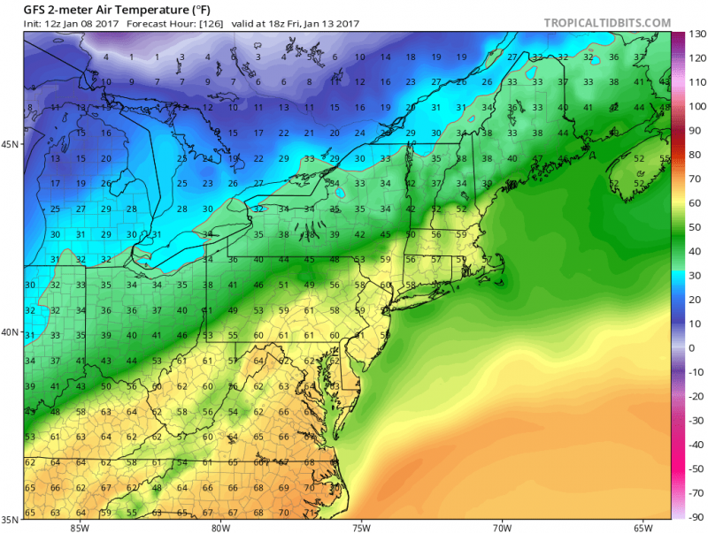 Computer models shows 50s (close to 60 degrees) by Friday. (Courtesy:tropicaltidbits.com)
As far as the weekend, the weather continues to look active as we will be in a battle zone between a cold high pressure system to our north and a series of disturbances that will slide through our area from the south. This will cause a chilly, wet weekend with a wintry mess possible especially Central and Northern NJ and N&W of Philly.
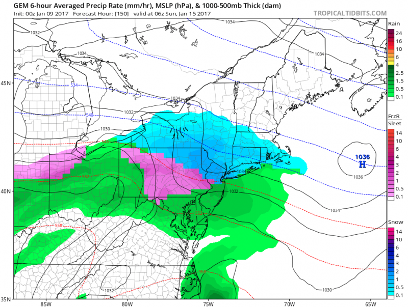 Computer models show a chilly, wet pattern this weekend for us, and wintry mess N&W of Philly, Northern NJ. (Courtesy: tropicaltidbits.com)
 Now that the weekend winter storm is past us, it time to look ahead to this week. We will have one more day of frigid temperatures before the freeze eases. High temperatures on Monday will struggle to reach 30 degrees despite another bright sunny day. Watch for re-freezing at night as any melting that occurs during the day will ice up again after dark.
 Lows Tuesday morning, not as frigid, but still below freezing.
Tuesday morning will probably be our last time we will see temperatures below freezing for at least the next 10 days as High Pressure slides off the coast and southwest winds will begin to erode the frigid air. This will allow temperatures will climb back above normal (mid 40s).
 Computer models show a ridge of High Pressure off of the Southeast U.S. which pushes milder air into our area. (Courtesy:tropicaltidbits.com)
 For the remainder of the week, a mild southwest flow will keep high temperatures in the upper 50s (possible 60) for Thursday and Friday. A cold front will approach late Friday with the threat of some showers.
 Computer models shows 50s (close to 60 degrees) by Friday. (Courtesy:tropicaltidbits.com)
As far as the weekend, the weather continues to look active as we will be in a battle zone between a cold high pressure system to our north and a series of disturbances that will slide through our area from the south. This will cause a chilly, wet weekend with a wintry mess possible especially Central and Northern NJ and N&W of Philly.
 Computer models show a chilly, wet pattern this weekend for us, and wintry mess N&W of Philly, Northern NJ. (Courtesy: tropicaltidbits.com)