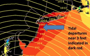
The National Weather Service predicts tides across much of the Jersey Shore that could be three feet above an already high new moon tide on Friday and Saturday.
Forecasters are predicting that a major snowstorm could affect millions across the East Coast at the end of the week.
With the track and temperatures still uncertain, it remains unclear what impact the storm will have in Ocean City.
But this much is clear: Full-moon tides will coincide with the arrival of the storm. If its anticipated 30- to 40-mph northeast coastal winds and heavy precipitation materialize, Ocean City can expect tidal flooding.
High tides (at the Ninth Street Bridge on Ocean City's flood-prone bay side) will be at the following times:
- 6:42 a.m. Friday (4.3 feet mean low water)
- 7:09 p.m. Friday (3.6 feet)
- 7:28 a.m. Saturday (4.3 feet)
- 7:54 p.m. Saturday (3.7 feet)
Residents of low-lying streets may want to be prepared to move vehicles to higher ground. The astronomical tide height predictions for this weekend are similar to the new moon tide that flooded Ocean City streets two weeks ago. These predictions don't take into account any of the wind or rain that can increase the flooding. (
See our chart of historic Ocean City flood levels.)
The coastal storm also could erode Ocean City's newly replenished beaches at the north and south ends, though a touch-up project is still scheduled to take place at the south end starting later this winter. (See "
Ocean City's South End Beaches to Get a Do-Over.")
Forecasters are tracking a major low-pressure system expected to move across the southern United States this week. The storm is expected to move over the Atlantic Ocean and track up the coast, moving past Ocean City from late Friday into Saturday.
Some inland areas on the East Coast could see as much as two feet of snow, but the potential for warmer coastal temperatures make the prediction of snow for Ocean City much more difficult.
"Due to the inherent uncertainty with systems this far out (currently this system is still out over the Pacific), we only produce snow amount forecasts for events within 72 hours (3 days). Thus, we probably won’t be producing a snow amount forecast for this event until at least Wednesday afternoon," the National Weather Service Mt. Holly Office reported on Monday.
A separate storm could bring less than an inch of new snow to Ocean City on Wednesday evening.
See Monday's National Weather Service briefing on the weekend event below.
[gview file="https://accessglobal.media.clients.ellingtoncms.com/siteimports/wp-content/uploads/2016/01/Weather-briefing-1-WFO-PHI-2016-01-18_4elI.pdf"]
 The National Weather Service predicts tides across much of the Jersey Shore that could be three feet above an already high new moon tide on Friday and Saturday.
Forecasters are predicting that a major snowstorm could affect millions across the East Coast at the end of the week.
With the track and temperatures still uncertain, it remains unclear what impact the storm will have in Ocean City.
But this much is clear: Full-moon tides will coincide with the arrival of the storm. If its anticipated 30- to 40-mph northeast coastal winds and heavy precipitation materialize, Ocean City can expect tidal flooding.
High tides (at the Ninth Street Bridge on Ocean City's flood-prone bay side) will be at the following times: