At low tide early Friday morning (Oct. 2), the cliff line along the dunes at Fifth Street and Sixth Street shows the effects of a northeast gale that has been battering the beaches for more than a week.
Ocean City on Friday morning appears to have escaped the first high tides of an extended northeast gale without any damage.
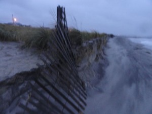
Dune fence has no sand to support it at Waverly Beach on Friday morning.
With no heavy rain at the time of high tides at 11:19 a.m. and midnight Thursday, the island saw only very limited street flooding. The second high tide did not reach the level of the first.
The greatest impact so far appears to be on the beaches where a northeast swell has been eating sand for more than week and is continuing to strengthen. The eroded beaches are more evident on the north end, where an Army Corps of Engineers replenishment project could begin later this month.
Ocean City gets good news with the Friday morning hurricane forecasts. Hurricane Joaquin, a Category 4 storm with 130 mph winds, is now projected to pass by hundreds of miles from the New Jersey coastline. In earlier forecasts, Ocean City was within the area of possible tracks.
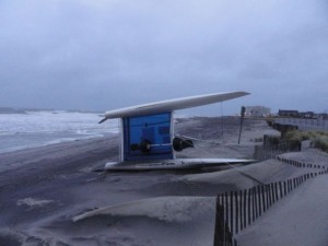
A catamaran is toppled at Atlantic Beach on the north end on Friday morning.
Peak tide level: 6.64 feet (Mean Low Water) at 11:48 a.m. Thursday, Oct. 1; and 6.45 feet at 12:12 a.m. on Friday, Oct. 2.
(
See tide level in real time at the Bayside Center on the 500 block of Bay Avenue in Ocean City. Add 2.77 to convert NAVD88 readings to MLW.)
How high is that tide? The 6.64 feet is the highest tide of the calendar year. It falls in what forecasters call “moderate tidal flooding” range of 6.5 feet to 7.5 feet. Superstorm Sandy, by comparison, was a record 10.02 feet on the MLW scale. (
See OCNJ Daily’s chart of historic and recent record flood levels.)
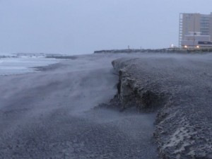
North Street Beach shows cliffing on Friday morning.
Observations: Without rain adding to the mix, not too much of the tidal flood made it onto the streets. Some of the usually flood-prone intersections were covered by water — likely backing up through the storm drain system. The beach at the north end is taking a pretty good beating with big storm surf crashing into the dunes at Fifth Street and Waverly Beach. The beaches are "cliffing" at several different points, including North Street. Unsecured catamarans are toppled.
The beaches at the south end are losing some of the new sand from the just-completed Army Corps of Engineers replenishment project. What was a very steep slope from the edge of the beach into deep water now appears to be more gradual with the redistribution of sand. The wind topped out a 28 mph on Thursday at 2:06 p.m., according to readings from an anemometer at 59th Street. Early on Friday, the wind is strong and steady but likely closer to 20 mph than the 50 mph gusts in the forecast for later today.
The Forecast: The National Weather Service forecast calls for 1 to 2 inches of rain to fall Friday with winds sustained at 30 to 40 mph and gusting up to 55 mph. The Saturday forecast calls for the rain to diminish but the wind to remain almost equally strong.

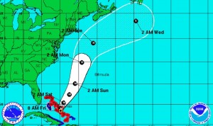
The projected track of Hurricane Joaquin as of 5 a.m. Friday from the National Hurricane Center.
Unrelated to the northeast gale, Category 4 Hurricane Joaquin now has sustained winds of 130 mph as it batters the Bahamas. Forecasters as of 5 a.m. Friday were favoring a track that would pass by Ocean City over the open ocean.
"The forecast models continue to indicate a track offshore of the United States' East Coast from the Carolinas to the Mid-Atlantic states, and the threat of direct impacts from Joaquin in those areas is decreasing," the National Hurricane Center reports. "However, there is still uncertainty in how close Joaquin could come to Bermuda, extreme southeastern New England/Cape Cod, and Nova Scotia during the next several days, and interests in those areas should continue to monitor the progress of the hurricane."
Big waves generated by the passing hurricane likely would affect Ocean City on Sunday and Monday. But the strong local northeast winds in the forecast through Monday would make surfing conditions less than ideal.
National Weather Service Briefing: Read the most current briefing from the NWS.
High Tides: Residents and visitors should be aware of the following high tides (on Ocean City’s bay side at the Ninth Street Bridge) and be prepared to move vehicles from flood-prone streets (particularly during heavy rainfall):
- Friday: 12:13 p.m.
- Saturday: 12:45 a.m. and 1:08 p.m.
- Sunday: 1:42 a.m. and 2:05 p.m.
Follow OCNJ Daily
Sign up for our free news updates from Ocean City. Check back with OCNJ Daily for photographs and reports on real-time conditions in Ocean City.
Postponements:
- The Ocean City School District will be closed on Friday.
- The Bike MS: City to Shore ride has been cancelled with no reschedule date.
- The HERO Foundation Walk has been rescheduled for Saturday, Oct. 10.
- The Ocean City Firefighters’ glowball golf event for Operation First Response has been postponed until Friday, Oct. 9.
- A Clean Ocean Action check presentation at Henry’s on the Boardwalk has been postponed with a rescheduled date to be determined.
- All games and practices for Ocean City Intermediate School have been cancelled for Thursday.
- The Ocean City High School away football game at St. Augustine’s Prep (originally scheduled for Friday) has been rescheduled for Thursday (Oct. 1) at 6 p.m.
- OCHS soccer and tennis games are postponed.
Ocean City Emergency Management Statement:
Read the latest update from 4 p.m. Thursday, Oct. 1.
 Dune fence has no sand to support it at Waverly Beach on Friday morning.
With no heavy rain at the time of high tides at 11:19 a.m. and midnight Thursday, the island saw only very limited street flooding. The second high tide did not reach the level of the first.
The greatest impact so far appears to be on the beaches where a northeast swell has been eating sand for more than week and is continuing to strengthen. The eroded beaches are more evident on the north end, where an Army Corps of Engineers replenishment project could begin later this month.
Ocean City gets good news with the Friday morning hurricane forecasts. Hurricane Joaquin, a Category 4 storm with 130 mph winds, is now projected to pass by hundreds of miles from the New Jersey coastline. In earlier forecasts, Ocean City was within the area of possible tracks.
 A catamaran is toppled at Atlantic Beach on the north end on Friday morning.
Peak tide level: 6.64 feet (Mean Low Water) at 11:48 a.m. Thursday, Oct. 1; and 6.45 feet at 12:12 a.m. on Friday, Oct. 2.
(See tide level in real time at the Bayside Center on the 500 block of Bay Avenue in Ocean City. Add 2.77 to convert NAVD88 readings to MLW.)
How high is that tide? The 6.64 feet is the highest tide of the calendar year. It falls in what forecasters call “moderate tidal flooding” range of 6.5 feet to 7.5 feet. Superstorm Sandy, by comparison, was a record 10.02 feet on the MLW scale. (See OCNJ Daily’s chart of historic and recent record flood levels.)
 North Street Beach shows cliffing on Friday morning.
Observations: Without rain adding to the mix, not too much of the tidal flood made it onto the streets. Some of the usually flood-prone intersections were covered by water — likely backing up through the storm drain system. The beach at the north end is taking a pretty good beating with big storm surf crashing into the dunes at Fifth Street and Waverly Beach. The beaches are "cliffing" at several different points, including North Street. Unsecured catamarans are toppled.
The beaches at the south end are losing some of the new sand from the just-completed Army Corps of Engineers replenishment project. What was a very steep slope from the edge of the beach into deep water now appears to be more gradual with the redistribution of sand. The wind topped out a 28 mph on Thursday at 2:06 p.m., according to readings from an anemometer at 59th Street. Early on Friday, the wind is strong and steady but likely closer to 20 mph than the 50 mph gusts in the forecast for later today.
The Forecast: The National Weather Service forecast calls for 1 to 2 inches of rain to fall Friday with winds sustained at 30 to 40 mph and gusting up to 55 mph. The Saturday forecast calls for the rain to diminish but the wind to remain almost equally strong.
