
A slight dusting of snow coats a section of the Ocean City Boardwalk in front of the Music Pier. A lot more snow could be coming this weekend.
Get the snow shovels, ice scrapers and rock salt ready.
Forecasters are warning of the likelihood of an “impactful winter storm” hitting the shore and the rest of South Jersey this weekend.
If the frigid temperatures gripping the region in recent days weren’t enough misery to go around, now comes the “increasing potential” for snow, according to the Cape May County Office of Emergency Management.
“Confidence in an impactful winter storm is increasing for this weekend. Snow appears most likely Saturday night through Sunday night, perhaps into early Monday morning. Specific details of amounts, timing and extent will become clearer with time,” the OEM said in a statement Tuesday evening.
The latest percentages for six inches of snow – or more – are in the 80 percent range for deep South Jersey, including the shore.
They are in the 40 percent to 60 percent range for areas northwest of I-95, the National Weather Service said.
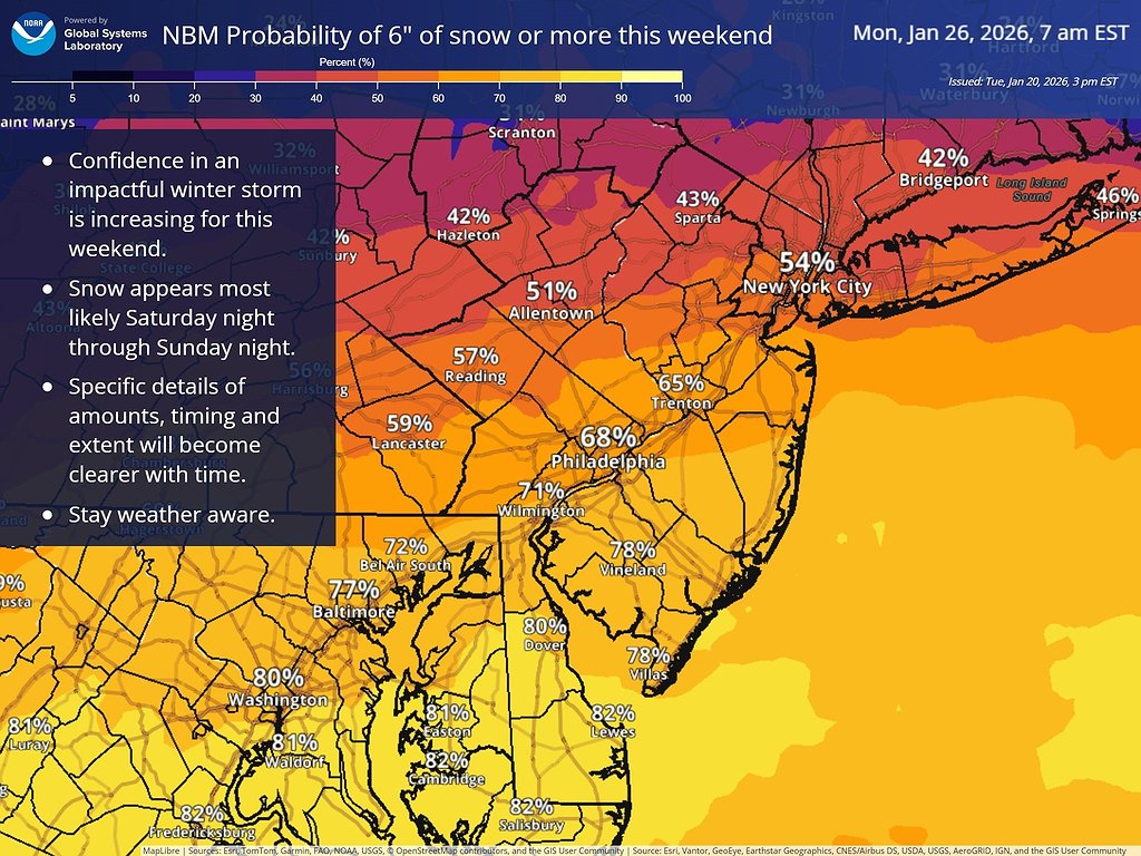 The probability of 6 inches of snow or more in South Jersey this weekend is about 80 percent. (Graphic courtesy of NOAA)
In the meantime, brutally cold weather will continue until Wednesday, including dangerously low wind chills Tuesday night before temperatures moderate briefly midweek.
Temperatures are expected to plummet into the teens Tuesday night, but could flirt with the single digits.
A slight warming trend will lift temperatures into the 40s on Wednesday and Thursday and high 30s on Friday, according to the forecast.
There could be a slight chance of snow on Friday night as temperatures drop overnight into the teens.
Then temperatures will come crashing down on Saturday and Sunday as the storm arrives with its bitterly cold conditions and the growing possibility of significant snowfall.
The high temperature in South Jersey for Saturday will be around 20 degrees, with the low sinking to the teens at night. On Sunday, the high temperature will be stuck in the 20s and the low will be in the teens, the National Weather Service says.
Frigid temperatures and even more snow could possibly linger into Monday, providing virtually no relief from the blast of Arctic air.


