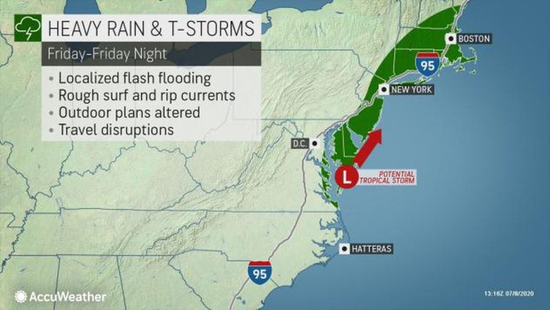
Graphic shows track of Tropical Storm Fay. (Courtesy of AccuWeather)
 By DONALD WITTKOWSKI
A tropical storm churning up the coast is expected to lash the Cape May County beach resorts with high winds, heavy rain and flash flooding on Friday, according to the forecast from the National Weather Service.
The low-pressure system strengthened to become Tropical Storm Fay. It is moving up from North Carolina’s Outer Banks and will drench the Jersey Coast with up to 3 inches of rain starting Thursday night into Friday afternoon, forecasters say.
Shortly after 5 p.m., the National Weather Service issued a tropical storm warning for Cape May, Atlantic, Ocean, Monmouth and Middlesex counties. As it clips the coast, the storm is expected to pack sustained winds of 30 to 35 mph and gusts up to 45 mph or higher.
The National Weather Service’s Mount Holly office has issued a Flash Flood Watch in effect for Ocean City from midnight Thursday until 4 p.m. Friday.
“Widespread rainfall of 1 to 3 inches is likely with locally higher amounts possible, according the NWS notification. High tide on the bay side of Ocean City (at the Ninth Street Bridge) will be at 12:56 p.m. Friday, but the NWS does not predict exceptionally high tides or tidal flooding,” Ocean City said in a weather advisory.
Forecasters warned in a tweet that there is also “an elevated risk for the development of dangerous rip currents” at the Jersey Shore.
Although flash flooding is expected, it is likely to be minor. However, heavier rain could produce even more significant flooding that could pose problems for vacationers not familiar with coastal storms, according to the NWS.
“With an onshore flow, minor tidal flooding is possible at the times of high tide at all locations (along the Atlantic coast and Delaware Bay) from late Thursday through Friday,” the weather service said in statement. “Heavy rain coincident with the high tide could cause more significant flooding issues, especially for visitors/vacationers unfamiliar with tidal flooding.”
Ocean City’s statement urges residents and visitors to closely monitor the forecast and weather conditions.
“Please don’t be caught off-guard,” the statement said. “Heavy rain flooding can impact parts of the island that don’t typically experience tidal flooding. Be prepared to move vehicles. The roads closer to the beach including Central and Wesley avenues are at higher elevation. These roads also offer the safest routes of travel across the length of the island.”
Rain is expected to arrive late Thursday and continue through Friday afternoon, but some showers could linger into Saturday morning.
