
National Weather Service graphic shows projected path of Tropical Storm Isaias as it moves up the coast. (Courtesy of National Weather Service)
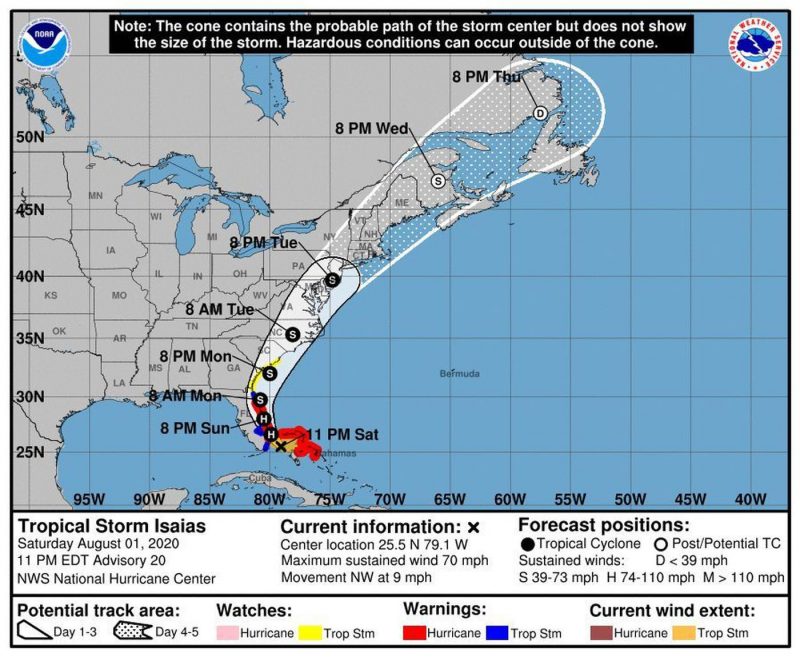 The National Weather Service has issued a Tropical Storm Watch and a Flash Flood Watch in effect for Ocean City in the coming days.
The Tropical Storm Watch warns of sustained winds of 40 mph to 50 mph with gusts up to 60 mph from Tuesday morning (Aug. 4) through Wednesday morning (Aug. 5). The Flash Flood Watch anticipates widespread amounts of 4 to 6 inches of rainfall with locally higher totals possible – from Monday evening (Aug. 3) through Tuesday evening (Aug. 4).
These advisories come as Tropical Storm Isaias is expected to take a track that will pass inland of Ocean City on Tuesday.
Residents and guests are asked to closely monitor the forecast and weather conditions. Please don’t be caught off-guard. Heavy rain flooding can impact parts of the island that don’t typically experience tidal flooding, including beach blocks.
Downpours associated with the storm could flood streets, and flooding could be worse during high tides at 9:04 p.m. Monday, 9:30 a.m. Tuesday, and 9:45 p.m. Tuesday. Because of a full moon, the Monday and Tuesday evening tides will be higher than normal.
Be prepared to move vehicles well in advance of these tides or any downpour. The roads closer to the beach including Central and Wesley avenues are at higher elevation. These roads also offer the safest routes of travel across the length of the island.
Parking will be available at the Trinity United Methodist Church at 20 North Shore Road in Marmora (please read this letter from Trinity
The National Weather Service has issued a Tropical Storm Watch and a Flash Flood Watch in effect for Ocean City in the coming days.
The Tropical Storm Watch warns of sustained winds of 40 mph to 50 mph with gusts up to 60 mph from Tuesday morning (Aug. 4) through Wednesday morning (Aug. 5). The Flash Flood Watch anticipates widespread amounts of 4 to 6 inches of rainfall with locally higher totals possible – from Monday evening (Aug. 3) through Tuesday evening (Aug. 4).
These advisories come as Tropical Storm Isaias is expected to take a track that will pass inland of Ocean City on Tuesday.
Residents and guests are asked to closely monitor the forecast and weather conditions. Please don’t be caught off-guard. Heavy rain flooding can impact parts of the island that don’t typically experience tidal flooding, including beach blocks.
Downpours associated with the storm could flood streets, and flooding could be worse during high tides at 9:04 p.m. Monday, 9:30 a.m. Tuesday, and 9:45 p.m. Tuesday. Because of a full moon, the Monday and Tuesday evening tides will be higher than normal.
Be prepared to move vehicles well in advance of these tides or any downpour. The roads closer to the beach including Central and Wesley avenues are at higher elevation. These roads also offer the safest routes of travel across the length of the island.
Parking will be available at the Trinity United Methodist Church at 20 North Shore Road in Marmora (please read this letter from Trinity 


