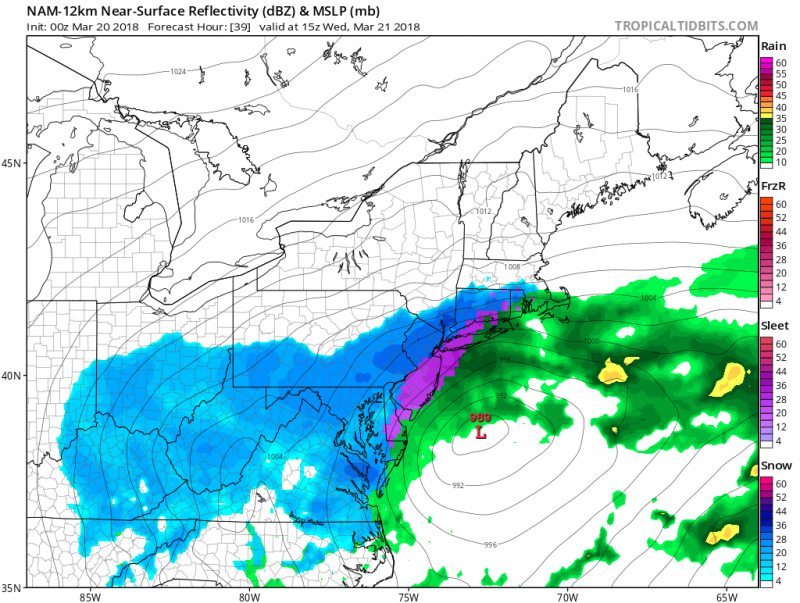
Oh great...not again! The fourth Nor'easter this month is set to strike our area. Get ready for more rain, snow, high winds and flooding for Tuesday and Wednesday. This storm is basically coming in two waves. The first wave will be mainly in the form of rain with some mixing possible.
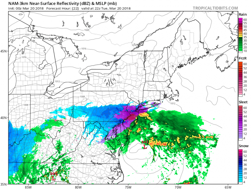 First wave moves through on Tuesday with rain and some mixing. (Courtesy:tropicaltidbits.com)
Winds will increase from the northeasterly direction 20-30mph with gusts to near 50mph. Temperatures will remain quite cold (in the 30s).
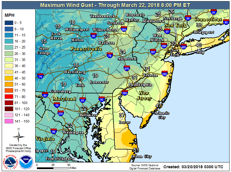 Forecast Peak Wind Gusts
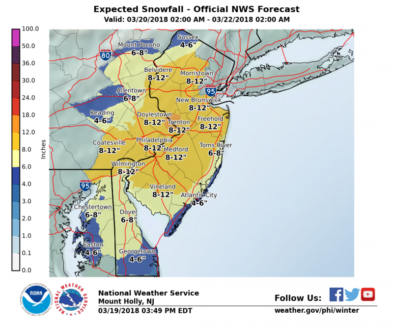
The main storm will develop offshore on Wednesday and pull colder air into the area changing and rain/mix to all snow during the day on Wednesday. Because it's late March, it will need to snow quite heavily to accumulate. Much like the last storm, we should pick up at least a couple inches of slushy snow and possibly a bit more. There are still some uncertainties with this storm which means expected snow amounts could change. Much high snow amounts will accumulate interior South Jersey and Philadelphia area where over 8" is possible.
What concerns me the most is the persistent onshore winds on Tuesday which will increase the threat of tidal flooding late Tuesday and Wednesday high tides. Unlike the previous Nor'easters, winds were more northerly and northwesterly which kept any significant flooding from occurring. Except last Wednesday's storm where we had one high tide cycle that reached moderate levels due to heavy rain and brief onshore flow.
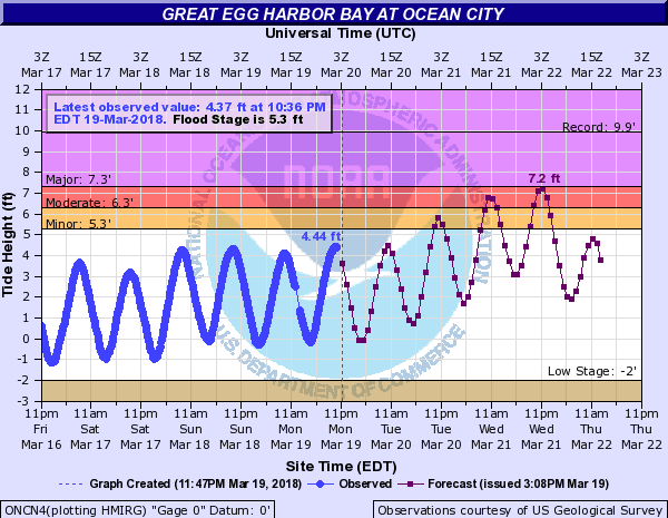
We could see similar conditions like that during Wednesday afternoon and again Wednesday night as forecast high tides could approach major flooding. High tides occur around 11AM Wednesday with back bay flooding occurring during the early afternoon. Moderate beach erosion is also expected as wave heights of 12 to 18 feet offshore will occur Tuesday night. Storm surge of 2 feet is expected Tuesday night and around 3 feet Wednesday morning. Many roadways will flood along West and Bay avenues Tuesday night and especially Wednesday afternoon and Wednesday night so be prepared and move your vehicles to higher ground.
 Oh great...not again! The fourth Nor'easter this month is set to strike our area. Get ready for more rain, snow, high winds and flooding for Tuesday and Wednesday. This storm is basically coming in two waves. The first wave will be mainly in the form of rain with some mixing possible.
 First wave moves through on Tuesday with rain and some mixing. (Courtesy:tropicaltidbits.com)
Winds will increase from the northeasterly direction 20-30mph with gusts to near 50mph. Temperatures will remain quite cold (in the 30s).
 Forecast Peak Wind Gusts
The main storm will develop offshore on Wednesday and pull colder air into the area changing and rain/mix to all snow during the day on Wednesday. Because it's late March, it will need to snow quite heavily to accumulate. Much like the last storm, we should pick up at least a couple inches of slushy snow and possibly a bit more. There are still some uncertainties with this storm which means expected snow amounts could change. Much high snow amounts will accumulate interior South Jersey and Philadelphia area where over 8" is possible.
 What concerns me the most is the persistent onshore winds on Tuesday which will increase the threat of tidal flooding late Tuesday and Wednesday high tides. Unlike the previous Nor'easters, winds were more northerly and northwesterly which kept any significant flooding from occurring. Except last Wednesday's storm where we had one high tide cycle that reached moderate levels due to heavy rain and brief onshore flow.
 We could see similar conditions like that during Wednesday afternoon and again Wednesday night as forecast high tides could approach major flooding. High tides occur around 11AM Wednesday with back bay flooding occurring during the early afternoon. Moderate beach erosion is also expected as wave heights of 12 to 18 feet offshore will occur Tuesday night. Storm surge of 2 feet is expected Tuesday night and around 3 feet Wednesday morning. Many roadways will flood along West and Bay avenues Tuesday night and especially Wednesday afternoon and Wednesday night so be prepared and move your vehicles to higher ground.