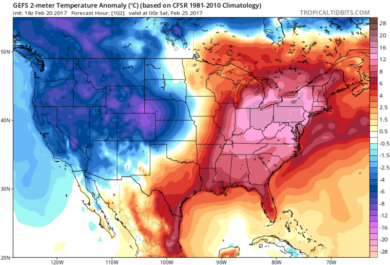
After a brief cool down, the unseasonably "warm" air will return by midweek and continue into the weekend. Temperatures will feel more like April as strong High Pressure will sit off the East Coast and continue to push mild air our way. However, with ocean temperatures still around 40 degrees, winds blowing from the southerly direction will keep the coast much cooler than the mainland.
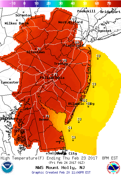
Temperatures on Thursday will hit 70 degrees inland while the cooler ocean will keep us mainly in the 50s.
Unlike last weekend, most of the week will feature a good deal of clouds with periods of sunshine. While most of the week will be dry, there will be a few chances of a sprinkle or brief shower. A better chance of showers (or even a t'storm) will arrive on Saturday as a cold front will approach which will put an end to the milder temperatures.
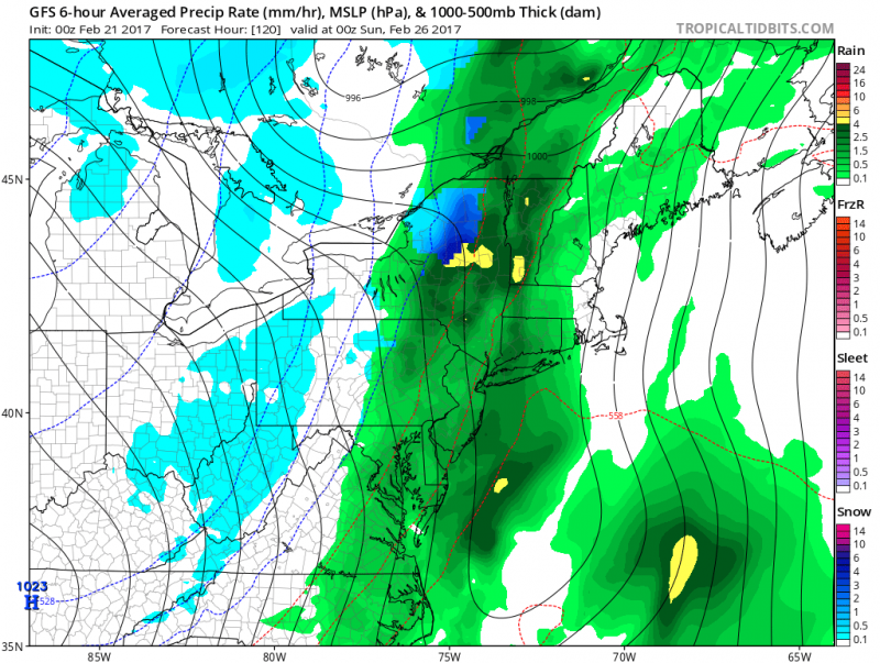 Computer models show a good chance of showers arriving by Saturday. (Courtesy: tropicaltidbits.com)
Despite the next cool shot on Sunday, high temperatures will still reach around 50 degrees on Sunday. Beyond that we will continue to remain above normal through the remainder of February.
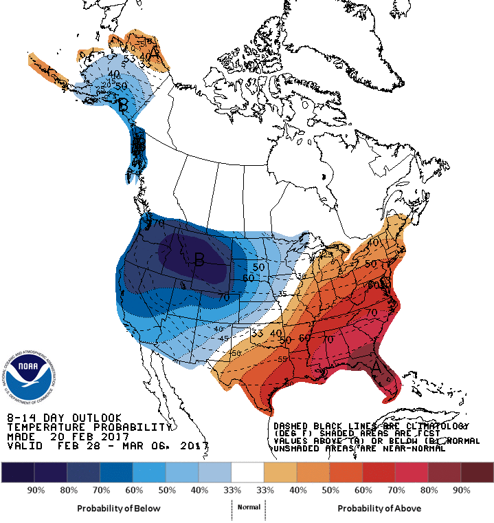 NOAA: 8-14 day outlook which takes us into the first week of March shows above normal temperatures continue.
Is Winter Over?
As we exit the last month of the Meteorological Winter (December, January & February), March is notorious for rapid changes in the weather. The Jetsteam is still rather strong in March which can cause active patterns. Increasingly warm, moist air from the Gulf of Mexico and winter's last gasp of Canadian Arctic Air trying to surge south causes wide temperature differences across the nation. This sometimes produces our late season snows, heavy rain and flooding with rapid developing coastal storms. Fortunately, with the sun angle rising higher in the sky, melting helps the snow disappear much quicker. While monthly forecasts are staring to look like winter could be behind us, this season's pattern has shown that quick blasts of cold air can still happen. Even though any blast would be short lived.
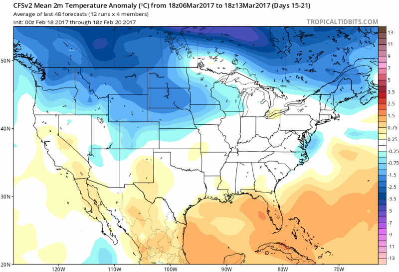
Computer models show monthly temperature forecasts return to near normal or just below normal, (High in the 40s), especially by the second week of March. Overall the weather pattern for March does not show any late season cold blasts which would give us a shot at any significant snowfall but does not show any surges of warm air either. March could end of being a month of near normal temperatures as high temperatures will generally be in the 40s & 50s.
 After a brief cool down, the unseasonably "warm" air will return by midweek and continue into the weekend. Temperatures will feel more like April as strong High Pressure will sit off the East Coast and continue to push mild air our way. However, with ocean temperatures still around 40 degrees, winds blowing from the southerly direction will keep the coast much cooler than the mainland.
 Temperatures on Thursday will hit 70 degrees inland while the cooler ocean will keep us mainly in the 50s.
Unlike last weekend, most of the week will feature a good deal of clouds with periods of sunshine. While most of the week will be dry, there will be a few chances of a sprinkle or brief shower. A better chance of showers (or even a t'storm) will arrive on Saturday as a cold front will approach which will put an end to the milder temperatures.
 Computer models show a good chance of showers arriving by Saturday. (Courtesy: tropicaltidbits.com)
Despite the next cool shot on Sunday, high temperatures will still reach around 50 degrees on Sunday. Beyond that we will continue to remain above normal through the remainder of February.
 NOAA: 8-14 day outlook which takes us into the first week of March shows above normal temperatures continue.
Is Winter Over?
As we exit the last month of the Meteorological Winter (December, January & February), March is notorious for rapid changes in the weather. The Jetsteam is still rather strong in March which can cause active patterns. Increasingly warm, moist air from the Gulf of Mexico and winter's last gasp of Canadian Arctic Air trying to surge south causes wide temperature differences across the nation. This sometimes produces our late season snows, heavy rain and flooding with rapid developing coastal storms. Fortunately, with the sun angle rising higher in the sky, melting helps the snow disappear much quicker. While monthly forecasts are staring to look like winter could be behind us, this season's pattern has shown that quick blasts of cold air can still happen. Even though any blast would be short lived.
 Computer models show monthly temperature forecasts return to near normal or just below normal, (High in the 40s), especially by the second week of March. Overall the weather pattern for March does not show any late season cold blasts which would give us a shot at any significant snowfall but does not show any surges of warm air either. March could end of being a month of near normal temperatures as high temperatures will generally be in the 40s & 50s.