While we enjoyed a great first half of our weekend, the 2
nd half we won’t be so lucky. We basically will have 2 rounds of showers. The first round of showers will move in for the early Sunday morning with a rumble of thunder possible too as a warm front slides to our north. Breezy southerly winds will keep us warm and humid through the day. Expect a dry period during the afternoon hours possibly even some sun. The next round is the one we have to watch out for. Depending on the amount of sun, we could see some hefty storms roll into Ocean City into the evening/nighttime hours
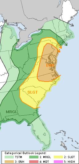
The Storm Prediction Center has placed us in an enhanced risk of severe storms. The biggest threat will be strong gusty winds and heavy rain. There is still a threat of some hail and even the outside chance of a tornado is possible. So keep an eye to the sky Sunday evening.
Brief note for Saturday evening: Between the onshore flow and a new moon, tides will be running slightly above normal which will cause some street flooding. With more cars on island as we enter the summer season, be mindful of where you park your car.
FORECAST
Sunday: Temps 77
Scattered showers, t’storm mainly in the morning. Some breaks possible in the afternoon. Line of strong to severe storms in the evening. Storms may contain strong damaging winds, heavy rain, hail.
Winds: South 10-15mph, higher gusts during t’storms in the evening.
UV Index: Low in the morning, High-Very High possible in the afternoon (depends on sunshine)
Monday: Mostly sunny, warmer.
Temps: 83.
Winds: West 10-15 mph
UV Index: Very High


