There are two common questions on a barrier island with little elevation to hold back a rising tide: “How bad is it going to be?” and “How bad was it?”
For 2015, OCNJ Daily is going to give its best shot at providing information to help folks answer both queries about storm flooding.
We’ve transcribed a record board to provide context on historic flood levels in Ocean City — many in recent memory. And we’ll add 2015 storms to a chart to see how they compare. We’ll also try to give as much unembellished forecast information as possible when there’s a legitimate threat of flooding.
The questions are not purely intellectual. Property owners, residents and visitors often need reliable information to protect vehicles and structures from flood damage.
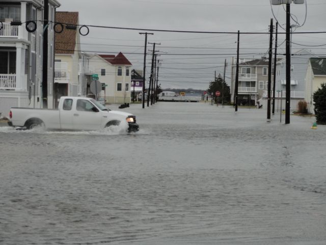
The questions are not always easy to answer. A July 10 (2014) rain storm, for instance, arrived on a not-particularly-high tide (2.76 feet NAVD88) but dumped more than four inches of rain on Ocean City in a few hours (while other areas nearby saw less than 2 inches of rain). With nowhere for the water to drain, the island saw street flooding comparable to that of a nor’easter earlier this month with a tide of 4.52 feet.
The best tool for making consistent comparisons is a tide gauge at the Bayside Center in Ocean City on the bay between Fifth and Sixth streets. The solar-powered gauge was installed on May 3, 2011, and it reports tide levels in real time (and historically) on the NAVD88 scale, which is now used by FEMA to determine the “base flood elevations” for safe construction and low federal flood insurance rates.
(The NGVD 1929 datum is the scale that appears on most flood elevation certificates in Ocean City, and the Mean Low Water — MLW — scale is commonly used in weather forecasts. They appear with NAVD88 in the record chart below.)
Superstorm Sandy brought the highest recorded water levels in Ocean City (7.25 feet NAVD88) and the FEMA now recommends building elevated homes at 8, 9 or 10 feet on the same scale, depending on where in Ocean City properties are located.
The following record chart is from information compiled by the City of Ocean City Engineering Department and is based on readings from the new Bayside Center tide gauge and historically from flood markings made at Wallace Hardware at Eighth Street and West Avenue.
The new chart will try to add rainfall and wind information to reported tide levels to help create a resource that might help create a knowledge base on how future storms could affect the island.
[table caption=”Ocean City Record Flood Levels” width=”900″ colwidth=”20|100|50″ colalign=”left|left|left|left|left”]
Date,Storm Name,NAVD1988,MLW,NGVD1929,Notes
10/29/12,Superstorm Sandy,7.25,10.02,8.50,Hybrid Cat 1 hurricane/winter storm makes landfall 12 miles north of O.C. on full-moon tide. 6.72 inches of rain in Beesley’s Point. Top O.C. wind gust 70.2 mph. But calm winds in eye of storm spare O.C. during highest tide.
9/15/44,1944 Hurricane,6.65,9.42,7.90,Cat 2 hurricane destroys Jersey Shore on way to landfall on Long Island.
3/6/62 to 3/8/62,Storm of ‘62,6.35,9.12,7.60,Three-day nor’easter batters Ocean City with 25-foot seas and 80+ mph winds.
12/11/92,December ’92 Nor’easter,6.23,9.00,7.48,Slow-moving nor’easter with 80 mph winds caused the most flooding since the Storm of ’62.
10/31/91,The Perfect Storm,6.00,8.77,7.25,Author Sebastian Junger dubbed the merger of Hurricane Grace and a massive nor’easter “The Perfect Storm.” It destroyed parts of the boardwalk in Ocean City.
9/27/85,Hurricane Gloria,5.75,8.52,7.00,Cat 1 hurricane hits the Outer Banks then Long Island
11/11/09 to 11/14/09, November 2009 Nor’easter,5.25,8.02,6.50,Three-day nor’easter levels dunes at the north end of the island
[/table]
[table caption=”2014-2015 Storms” width=”900″ colwidth=”20|100|50″ colalign=”left|left|left|left|left|left”]
Date,Storm Name,NAVD1988,Rainfall,Top Winds,Notes
12/9/14,December 2014 Nor’easter,4.52,2.08 in.,36 mph,Flooding from a winter nor’easter closed Ocean City schools — but heavy overnight rain stopped before morning high tide.
[/table]
Note: Rainfall and wind information in the 2014-2015 chart is from official readings at Atlantic City International Airport. For future storms, we’ll try to obtain local information for Ocean City.
__________
Sign up for OCNJ Daily’s free newsletter and breaking news alerts
“Like” us on Facebook


