The six-month Atlantic Ocean hurricane season begins today (June 1), and the National Oceanic and Atmospheric Administration’s Climate Prediction Center is forecasting a near-normal or below-normal season.
Long-range hurricane forecasts are of limited value, because meteorologists can’t predict the intensity or track of any individual storm so far in advance. But forecasters can successfully identify factors that make the development of hurricanes more likely.
“The main driver of this year’s outlook is the anticipated development of El Niño this summer,” NOAA writes in its 2014 outlook. “El Niño causes stronger wind shear, which reduces the number and intensity of tropical storms and hurricanes. El Niño can also strengthen the trade winds and increase the atmospheric stability across the tropical Atlantic, making it more difficult for cloud systems coming off of Africa to intensify into tropical storms.”
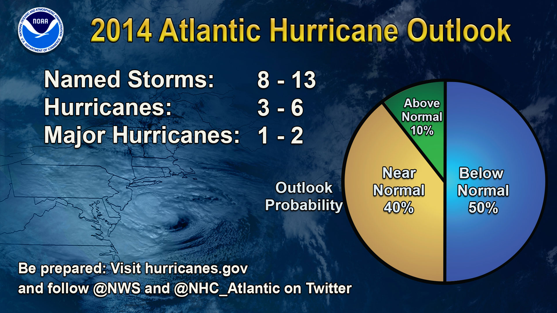
NOAA predicts a 50-percent chance of a below-normal season, a 40-percent chance of a near-normal season and only a 10-percent chance of an above-normal season.
For the hurricane season, which ends Nov. 30, NOAA predicts a 70-percent likelihood of eight to 13 named storms (winds of 39 mph or higher), of which three to six could become hurricanes (winds of 74 mph or higher), including one to two major hurricanes (Category 3, 4 or 5; winds of 111 mph or higher).
These numbers are near or below the seasonal averages of 12 named storms, six hurricanes and three major hurricanes, based on the average from 1981 to 2010. The Atlantic hurricane region includes the North Atlantic Ocean, Caribbean Sea and Gulf of Mexico.
Gerry Bell, Ph.D., lead seasonal hurricane forecaster with NOAA’s Climate Prediction Center, said the Atlantic – which has seen above-normal seasons in 12 of the last 20 years – has been in an era of high activity for hurricanes since 1995.
“Atmospheric and oceanic conditions across the tropical Pacific are already taking on some El Niño characteristics. Also, we are currently seeing strong trade winds and wind shear over the tropical Atlantic, and NOAA’s climate models predict these conditions will persist, in part because of El Niño,” Bell said. “The expectation of near-average Atlantic Ocean temperatures this season, rather than the above-average temperatures seen since 1995, also suggests fewer Atlantic hurricanes.”
NOAA is rolling out new tools at the National Hurricane Center this year. An experimental mapping tool will be used to show communities their storm surge flood threat. The map will be issued for coastal areas when a hurricane or tropical storm watch is first issued, or approximately 48 hours before the anticipated onset of tropical storm force winds. The map will show land areas where storm surge could occur and how high above ground the water could reach in those areas.
NOAA’s seasonal hurricane outlook is not a hurricane landfall forecast; it does not predict how many storms will hit land or where a storm will strike. Forecasts for individual storms and their impacts will be provided throughout the season by NOAA’s National Hurricane Center.
— From NOAA National Hurricane Center news release
__________
Sign up for OCNJ Daily’s free newsletter
“Like” us on Facebook


