
After a great weekend and temperatures in the 50s, a change in the weather pattern will keep Ocean City in a wet, unsettled pattern for most of this week. First, a weak disturbance will move through our area this evening bringing some rain. Rain amounts expected to be on the lighter side (around .25”)
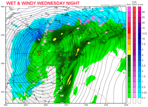
High pressure will build back in for Monday with a return to sunshine but a little cooler as temperatures climb into the upper 40s. Then we watch the next storm for Tuesday through Thursday. The track of the storm will remain to our west which is good news, this keeps us wet (not white) and reduces our coastal flooding threat. However, sea levels will remain high due to the full moon and a northeasterly flow developing by Tuesday. It is possible some minor tidal flooding could occur on Tuesday and/or Wednesday. Winds will switch to the easterly direction on Wednesday and then swing to the southerly direction Wednesday night and will become quite windy (25-30 mph with gusts over 30mph) as the storm intensifies to our west.
Rain will be rather light when if first arrives later in the day on Tuesday. The heaviest rain will fall Wednesday night. Total rainfall could reach 1.5” and some street flooding could occur during times of heavy rain on Wednesday.
Most of the rain should leave our area early Thursday morning. Winds will swing from the west bringing in cooler, drier conditions for the remainder of the week. Highs late in the week will top out around 40 degrees with lows near freezing.


